| Origin & Development | |
|
Legends & Fairy tales • Earth's Crust Thickness • Underwater Relief • Landscapes • History & Formation • Seismic Activity • | |
| History of Lake Baikal | |
|
History of Explorations • Inhabitants & Settlers • First maps of Baikal • Archaeological Sites • | |
| Lake Baikal Climate | |
|
Introduction • Fogs • Winds & Waves • Ice Conditions • | |
| Fauna & Vegetation | |
|
Mammals • Baikal seal - Nerpa • Ichthyofauna • Invertebrates • Vegetation • | |
| Water of Lake Baikal | |
|
Colour • Transparency • Temperature • Pressure • Depth • Currents • Budget • Chemical Composition • Pollution • | |
| Recreational Areas | |
|
Circumbaikal Railway • Peschanaya Bays • Olkhon Island • Chivirkuysky Gulf • Wooden Irkutsk • Trans-Siberian Railway • | |
| People of Lake Baikal | |
|
People of Siberia • Buryat nation in Baikal • Russians in Baikal • | |
|
| |
| First Maps of Baikal Lake The Russian explorers were accurate at making up the "skaski", the first descriptions of a new place. These data had served as invaluable material for the initial Russian and European investigations of Siberia. The Russian pioneers' service is even the more remarkable, as not so many of them were among the literate part of the population. Innumerable "otpiski" (replies, reports), "skaski" (the first description of a new place) and "chertezhi" (drafts) of the Russian explorers were detailed and priceless since at that time there was only limited information on the main Siberian rivers, mountain ranges and previously unknown people inhabiting this area, on peculiarities of nature and never heard of before riches of the lands. 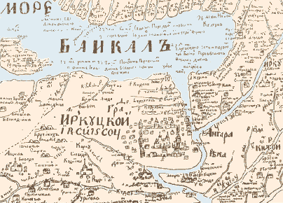 The first drafts brought by the explorers from their expeditions did not meet the standards of European cartography. However, they fully satisfied the practical goals that were planned for the exploration of Siberia in the XVII th century, moreover, these maps were made thoroughly and conscientiously.
» click here to see the modern map of lake Baikal (115 Kb / scale: 1:750000) | |