| Origin & Development | |
|
Legends & Fairy tales • Earth's Crust Thickness • Underwater Relief • Landscapes • History & Formation • Seismic Activity • | |
| History of Lake Baikal | |
|
History of Explorations • Inhabitants & Settlers • First maps of Baikal • Archaeological Sites • | |
| Lake Baikal Climate | |
|
Introduction • Fogs • Winds & Waves • Ice Conditions • | |
| Fauna & Vegetation | |
|
Mammals • Baikal seal - Nerpa • Ichthyofauna • Invertebrates • Vegetation • | |
| Water of Lake Baikal | |
|
Colour • Transparency • Temperature • Pressure • Depth • Currents • Budget • Chemical Composition • Pollution • | |
| Recreational Areas | |
|
Circumbaikal Railway • Peschanaya Bays • Olkhon Island • Chivirkuysky Gulf • Wooden Irkutsk • Trans-Siberian Railway • | |
| People of Lake Baikal | |
|
People of Siberia • Buryat nation in Baikal • Russians in Baikal • | |
|
| |
| The face of Baikal - Water © A description of Baikal's water & questions concerning its pollution by S.A.Gurulev Transparency of Lake Baikal Water
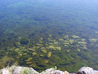
The high degree of transparency of Baikal's waters is due to a number of factors. The fact that the lake's shores are made up mainly of rock; that there are few shallow areas along the shores with the result that there is little stirring up of floor silts; also that, under the influence of complex biochemical processes including the activity of Baikal organisms, suspended organic matter in part decays and in part is transported to considerable depths to be deposited in sediment; diatomic algae assimilate silicon from non organic mineral suspensions drawing it into floor sediments. Baikal acts like a kind of treatment plant, turning out clear, pure water. Over the summer period the transparency of Baikal changes depending on the quantity of sediment brought to the lake by rivers and the growth of plankton. Transparency is low at the mouths of rivers and near them. The highest degree of transparency can be observed in late autumn and early spring. In its transparency Baikal takes the lead over the Caspian Sea (25 metres), and lakes Sevan (Armenia) and Issyk-Kul (20 metres). In this respect it competes with various seas, taking second place only to the extremely transparent Sargasso Sea (66 metres). Variations in the transparency of Baikal's water with depth has been studied in the southern part by the hydrologists M.E.Li, G.G.Neuimin and I.P.Sherstyankin, using a marine impulse photometer. Transparency at depth depends on the vertical distribution of temperature and chemical components. Three layers of water have been defined according to their degree of translucency: surface, deep water and bottom. The surface layer goes down to a depth of 250 - 300 metres (where the water temperature changes abruptly). In the deep water layer the transparency increases dramatically. This is where the clearest waters are. The lower boundary of the deep water zone goes down to 300 - 400 metres above the lake floor. In the bottom layer transparency varies: in some cases it decreases, in others it remains the same, and in still others it even increases. So it is possible to find very transparent water even at the bottom of Baikal. In general, the transparency here depends on the presence or absence of floor currents. The transparency of Baikal's waters varies at its different shores. The transparency changes abruptly at a depth of 200 - 250 metres (the isoclines are closely spaced). The high frequency of the isoclines begins closer to the surface at the steep western shores and gradually drops towards the eastern shore. A similar distribution of transparency can be explained by the undercurrent of transparent deep waters along the western shores of the lake. Baikal's fishermen differentiate the lake's waters according to their transparency and colour very well. They catch omul, Baikal's commercial fish, not only along the shores and at the surface, but also in the open sea at great depths by letting down special deep water nets to 400 metres. The transparency and colour of the water are important signs for fishermen. They call deep transparent waters "golomyanniye" "deep, open waters" and differentiate them from coastal "grey" and "white" waters. In the XVII century Russians brought the word "golomen" to Baikal from Northern Rus. Here it has the meaning - fathomless places at Baikal. This is how the most transparent waters, as representative of great depth, came to be known as "golomyanny". It is from this that Baikal's most exotic fish received its name, the endemic, deep water, golomyanka. |
